Project Description
To enhance persistence and prevent further local extinctions of Malleefowl in agricultural landscapes, habitat restoration and management is necessary.
Aim:
Develop a spatially explicit decision support tool to inform investment in Malleefowl conservation actions:
- identify priority habitat in Malleefowl neighourhoods (sensu Short and Parsons 2008) within the Gunduwa Region;
- estimate the expected relative benefits of recommended management interventions; and
- identify where specific actions should be prioritised (ie habitat restoration, assisted regeneration, weed and predator management) at a scale relevant to implementation
Activity:
A preliminary spatial analysis report to inform workshops has been completed. A meeting was held between NACC and Greening Australia to discuss results has been completed.
Results from the report (methodology exert):
Marxan required the following files: planning units, conservation features, planning units versus conservation features, boundary lengths and input parameters.
Firstly the landscape is divided up into a hexagonal grid, which are made up of 1,000ha ‘planning units’ and given a remnancy cost, the highest being (1) if a planning unit was entirely vegetated and lowest being (0) if it was entirely cleared. (vegetation that had the lowest value to Malleefowl (Blair Parson, per com), and which covered more than 30% of a planning unit was excluded from the analysis.
Three conservation targets were used in the analysis:
- the presence of Malleefowl since 1990 (using data from the Department of Water and Environment Regulation) within a 4km area of a planning unit;
- the amount of high value vegetation for Malleefowl in a planning unit;
- the likelihood that the planning unit fell within a Malleefowl neighborhood (Blair Parsons, per com).
Marxan: Boundary length refers to the length of shared boundaries between planning units and allows reserve solutions to be more connected. Boundary length was calculated using the ArcMarxan Toolbox. Boundary length was not used in some instances, as the conservation targets assisted in making solutions more connected.
Outcomes:
The neighbourhood data generated by this project is shared with all landholders that approach NACC NRM for revegetation. Through networks with other revegetation providers (such as Greening Australia) the priority is set to the known neighbourhoods when Malleefowl is the specific outcome.
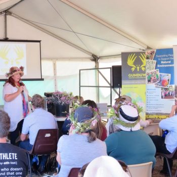
Two community events were held to engage with stakeholders in the Gunduwa region, and adjacent agricultural zones. Traditional owners groups attended the Dalwallinu event and continued to contribute to Malleefowl conservation activities across the region.
The activities to achieve this were the development of Marxan modelling, consultation with regional stakeholders and informed priority investment. The project has assisted in identifying priority neighbourhoods, to which NACC NRM has applied regional investment.
A NACC Notes article describing the project and specifically promoting the workshop outcomes has been published and a media release completed.
Project Details
- OrganisationNorthern Agricultural Catchments Council
- Year2018
- Funding$49,300.00